Lake Anna, VA’s deepest point is 80 feet, which is only half the width of a football field, and a quarter the length from goal to goal.
In comparison, Smith Mountain Lake in southwest Virginia, is 250 feet deep, which is almost two times the length of a football field.
Lake Anna’s maximum length is 17 miles. It’s surface area spans 13,000 ares.
Lake Anna is a significant freshwater inland reservoir in Virginia, spans 13,000 acres (53 km2) and sits approximately 72 miles (116 km) south of Washington, D.C., stretching across Louisa and Spotsylvania counties with a portion extending into Orange County. Easily accessible from various cities including Fredericksburg, Richmond, Charlottesville, Northern Virginia, and the nation’s capital, Lake Anna stands as one of the favored recreational destinations in the state.
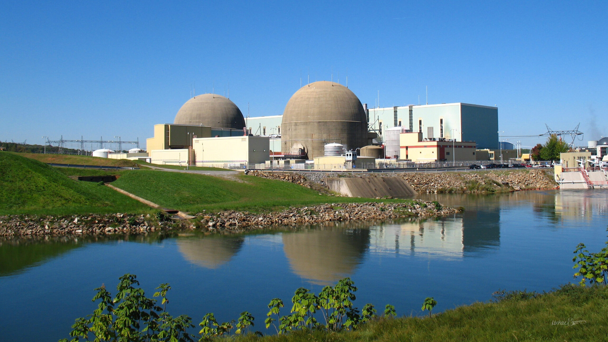
Originating from the North Anna Dam on the North Anna River at coordinates 38°00′47″N 77°42′46″W, Lake Anna’s creation traces back to 1968 when Virginia Electric and Power Company (now Dominion) acquired 18,000 acres (73 km2) of farmland in three counties bordering the North Anna and Pamunkey rivers. This acquisition aimed to supply clean water for cooling the adjacent North Anna Nuclear Generating Station. Despite initial projections estimating a three-year period to fill the lake, the process was expedited to just 18 months, aided by rainfall from Hurricane Agnes. Consequently, communities began emerging around the lake, with approximately 120 distinct communities now adorning its shores. The first reactor commenced commercial operation in June 1978, with a second unit following suit in December 1980.
Lake Anna spans roughly 17 miles (27 km) from end to end, boasting 200 miles (320 km) of shoreline. The lake is bisected by three stone dikes, delineating a public side, spanning around 9,000 acres (36 km2), and a private side, covering approximately 4,000 acres (16 km2).
The private side comprises three primary bodies of water interconnected by navigable canals, accessible solely to property owners and North Anna Power Station employees. Conversely, the public side hosts several marinas and boat launches, including one at an adjacent state park. Due to its function in cooling the power plant’s generators, the public side is known as the “cold” side, while the private side, receiving warm water discharge, is dubbed the “hot” side. This disparity in temperature extends the water sports season on the private side. However, concerns regarding the addition of a third reactor persist among environmentalists and property owners, fearing adverse impacts on water temperature and level, particularly on the private side.
The North Anna Dam, which forms Lake Anna, spans 5,000 feet in length and stands 90 feet tall. It features a spillway with three main radial gates, supplemented by smaller gates for regular discharges. With a hydroelectric power plant situated on its west side, the dam maintains a normal reservoir elevation of 250 feet.
Lake Anna’s aquatic ecosystem hosts various fish species including largemouth bass, bluegill, channel catfish, and more, while submerged vegetation such as Hydrilla verticillata contributes to its ecological diversity.
At its maximum depth of 80 feet, Lake Anna offers ample opportunities for recreation and exploration, attracting visitors from near and far.

Hi! I’m Jennifer Bailey and I partner with entrepreneurs who have massive ideas that could change the world. Most marketing is meaningless. Filled with empty promises, its only job is to bring in new traffic, new leads, and new customers. But I’ve drawn a line in the sand, and I’ve learned that marketing can do so much more than reach business goals and build profit. My methods give businesses the fire and soul they need to reach the right people, set the groundwork for sustainable relationships, and offer true value to the people on both the giving and receiving ends of marketing.
Subscribe for Updates
Sponsors
latest articles
Amazon, Dominion and Small Nuclear Reactors at Lake Anna?! Here are the facts.

First Frost/Freeze at Lake Anna
Bamboo Poses Growing Power Outage Risk in Virginia
Disaster Relief: Lake Anna Can Help
Louisa Arts Center Announces Expressions in Pastels Gallery Exhibit through November 22

Coyote Hole Brings the Future of Non-Alcoholic Craft Beverages to Lake Anna

Lake Anna, VA’s deepest point is 80 feet, which is only half the width of a football field, and a quarter the length from goal to goal.
In comparison, Smith Mountain Lake in southwest Virginia, is 250 feet deep, which is almost two times the length of a football field.
Lake Anna’s maximum length is 17 miles. It’s surface area spans 13,000 ares.
Lake Anna is a significant freshwater inland reservoir in Virginia, spans 13,000 acres (53 km2) and sits approximately 72 miles (116 km) south of Washington, D.C., stretching across Louisa and Spotsylvania counties with a portion extending into Orange County. Easily accessible from various cities including Fredericksburg, Richmond, Charlottesville, Northern Virginia, and the nation’s capital, Lake Anna stands as one of the favored recreational destinations in the state.
Originating from the North Anna Dam on the North Anna River at coordinates 38°00′47″N 77°42′46″W, Lake Anna’s creation traces back to 1968 when Virginia Electric and Power Company (now Dominion) acquired 18,000 acres (73 km2) of farmland in three counties bordering the North Anna and Pamunkey rivers. This acquisition aimed to supply clean water for cooling the adjacent North Anna Nuclear Generating Station. Despite initial projections estimating a three-year period to fill the lake, the process was expedited to just 18 months, aided by rainfall from Hurricane Agnes. Consequently, communities began emerging around the lake, with approximately 120 distinct communities now adorning its shores. The first reactor commenced commercial operation in June 1978, with a second unit following suit in December 1980.
Lake Anna spans roughly 17 miles (27 km) from end to end, boasting 200 miles (320 km) of shoreline. The lake is bisected by three stone dikes, delineating a public side, spanning around 9,000 acres (36 km2), and a private side, covering approximately 4,000 acres (16 km2).
The private side comprises three primary bodies of water interconnected by navigable canals, accessible solely to property owners and North Anna Power Station employees. Conversely, the public side hosts several marinas and boat launches, including one at an adjacent state park. Due to its function in cooling the power plant’s generators, the public side is known as the “cold” side, while the private side, receiving warm water discharge, is dubbed the “hot” side. This disparity in temperature extends the water sports season on the private side. However, concerns regarding the addition of a third reactor persist among environmentalists and property owners, fearing adverse impacts on water temperature and level, particularly on the private side.
The North Anna Dam, which forms Lake Anna, spans 5,000 feet in length and stands 90 feet tall. It features a spillway with three main radial gates, supplemented by smaller gates for regular discharges. With a hydroelectric power plant situated on its west side, the dam maintains a normal reservoir elevation of 250 feet.
Lake Anna’s aquatic ecosystem hosts various fish species including largemouth bass, bluegill, channel catfish, and more, while submerged vegetation such as Hydrilla verticillata contributes to its ecological diversity.
At its maximum depth of 80 feet, Lake Anna offers ample opportunities for recreation and exploration, attracting visitors from near and far.

Hi! I’m Jennifer Bailey and I partner with entrepreneurs who have massive ideas that could change the world. Most marketing is meaningless. Filled with empty promises, its only job is to bring in new traffic, new leads, and new customers. But I’ve drawn a line in the sand, and I’ve learned that marketing can do so much more than reach business goals and build profit. My methods give businesses the fire and soul they need to reach the right people, set the groundwork for sustainable relationships, and offer true value to the people on both the giving and receiving ends of marketing.
Subscribe for Updates
Sponsors
latest articles
Amazon, Dominion and Small Nuclear Reactors at Lake Anna?! Here are the facts.

First Frost/Freeze at Lake Anna
Bamboo Poses Growing Power Outage Risk in Virginia
Disaster Relief: Lake Anna Can Help
Louisa Arts Center Announces Expressions in Pastels Gallery Exhibit through November 22

Coyote Hole Brings the Future of Non-Alcoholic Craft Beverages to Lake Anna


All Ages Compete in Beauty Pageant for Lake Anna Rescue
Article By Jen Bailey

Wavemakers 2024: Movement for Positive Change
Article By David Mills


