Welcome to February, the month where we start a slow warming process as we move into the Spring season, but also a month where we still can get big snowstorms. High temperature averages start in the middle 40s, but rise into the lower 50s by the end of the month.
It’s a pleasure to join the Lake Anna Breeze™ team. These articles will be focused on general weather information and weather education to better prepare yourselves for what Mother Nature can offer up to the Lake Anna community.

Our winter this year has been dominated by the Pacific Ocean circulation known as El Nino.
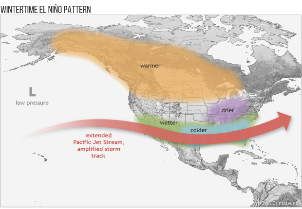
El Nino is defined by the warming of the eastern Pacific waters off the South American Coast into the Central Pacific. This warming helps to intensify the Subtropical Jet, which supports a more active stream of storms that usually cross the southern US and then ride up the East Coast. The warmth of the Gulf Stream provides additional thermal energy that can fuel explosive storms along the East Coast. These storms are called Nor’easters and can produce massive amounts of snow if enough cold air is available.
If there is not enough cold air in place, we can still have a Nor’easter, but they bring heavy rainfall. This happened with the storms from late November into January 2024 that ended our drought.
Historically, El Nino winters for VA are basically a 50/50 toss up on whether we get a big winter storm. East Coast snow storms are dependent on the timing of many smaller scale events/features that are difficult to predict on the scale of an El Nino event. Big snow events are fairly rare for our part of Virginia. We usually get a big snowstorm, which I define as 8-12” of snow, every 5-7 years.
The preferred surface pattern is cold High Pressure located over the interior Northeastern US/Southeast Canada. At the same time, we need an intensifying area of Low Pressure over the Southeastern US that moves northeast toward Virginia Beach.
The biggest February snowstorms for the Richmond area (Louisa records don’t go back very far) include 16.3” in 1899, 12.6” in 1936, and the most recent, 17.7” in 1983.
Forecasting these big storms is extremely difficult; usually Meteorologists have an idea, but we really can’t nail down the forecast until we get inside a 3–5-day window, where the models have access to all the needed observational data.
So don’t put your shovel or snow blower away just yet.
Tight Lines and Wear your PFD!

I grew up an Air Force Brat. Traveled the country and lived in Georgia, Maine, New York, Hawaii and Oklahoma.
I fell in love with the weather in Oklahoma. My father was transferred to Tinker AFB in 1973. While in Temporary housing (a mobile home, which is the standard in Oklahoma) I experienced my first severe thunderstorm with strong winds and hail the size of baseballs. The next day I was in the base library looking up books on weather. The rest is history.
I graduated from the University of Oklahoma in 1983 with a Bachelor’s Degree in Meteorology. The first two years we took Calculus, Differential equations, Physics, Chemistry and Computer science classes with the Engineering Students. It was a grind. My degree is actually from the College of Engineering. The last 2-3 year’s focus was on Meteorology including Observational networks (Satellite, Radar, Surface), Physics, Thermodynamics, Dynamics, Synoptic, Winter Weather, Severe Weather and Climatology.
My first job out of college was with a small forecasting company in Oklahoma City. I was immediately put on TV (OETA) and Radio (WKY) as their broadcast Meteorologist. After two years in broadcasting, I decided to pursue the National Weather Service route and got a position in Toledo, OH as an intern. After a couple of years, I was promoted to a forecaster position at the Cleveland Forecast office. I quickly moved into the Weather Preparedness position and was responsible for all the preparedness activities in the state of Ohio.
In 1992 I decided to pursue other forecast opportunities and moved to the Meteorological Operations Division of the National Meteorological Center in Washington, DC. This group is now called WPC (Weather Prediction Center). There I fine-tuned my forecasting of Synoptic Weather with my focus on Heavy Convective Rainfall and Winter Storms, under the supervision of Dr. Louis Uccellini. He has written several books on East Coast Winter storms. I was promoted to a Senior Branch Forecast position during my tenure at MOD. Part of my job was to teach weather classes at COMET (Cooperative Program for Operational Meteorology, Education, and Training).
In 2012 I was given the opportunity to start up a new weather support group with the FAA (Federal Aviation Administration) in Warrenton, VA at the ATCSSC (Air Traffic Control System Command Center). The ATCSCC is where the FAA identifies solutions to air traffic inefficiencies in the NAS (National Air Space) for the CONUS (Continental United State). Weather impacts are the biggest impact on Aviation with yearly losses over 20 billion dollars. My job was to help lower these inefficiencies/costs by providing weather impact briefings and forecasts in order to keep the air planes moving as safely and efficiently as possible.
I retired in 2022 and now am running Lake Anna Weather, LLC.
Subscribe for Updates
Sponsors
latest articles
Lake Anna Development Continues: Data Centers, Dominion Updates, Roundabout Plaza, New Golf Course & Phosphorus and Hydrilla Management Reports at the 2026 Lake Anna Summit
From Louisa County to Hospital Halls: How Virginia Poodles & Doodles Is Making a Broader Impact

Lake Anna Waterfront Property | Custom Lake Home for Sale | Lake Anna, VA
Puppy Culture, Playgrounds & Early Foundations: How Virginia Poodles & Doodles Raises Confident Companions [Sponsored]
![Featured image for “Puppy Culture, Playgrounds & Early Foundations: How Virginia Poodles & Doodles Raises Confident Companions [Sponsored]”](https://lakeanna.online/wp-content/uploads/2026/02/3-scaled.jpg)
The Lion’s Den 1837 Celebrates First Anniversary With Black Tie Evening of Fine Dining and Jazz
Five Decades of Innovation in Fishing, and Boating Sustainability at Lake Anna
Welcome to February, the month where we start a slow warming process as we move into the Spring season, but also a month where we still can get big snowstorms. High temperature averages start in the middle 40s, but rise into the lower 50s by the end of the month.
It’s a pleasure to join the Lake Anna Breeze™ team. These articles will be focused on general weather information and weather education to better prepare yourselves for what Mother Nature can offer up to the Lake Anna community.

Our winter this year has been dominated by the Pacific Ocean circulation known as El Nino.
El Nino is defined by the warming of the eastern Pacific waters off the South American Coast into the Central Pacific. This warming helps to intensify the Subtropical Jet, which supports a more active stream of storms that usually cross the southern US and then ride up the East Coast. The warmth of the Gulf Stream provides additional thermal energy that can fuel explosive storms along the East Coast. These storms are called Nor’easters and can produce massive amounts of snow if enough cold air is available.
If there is not enough cold air in place, we can still have a Nor’easter, but they bring heavy rainfall. This happened with the storms from late November into January 2024 that ended our drought.
Historically, El Nino winters for VA are basically a 50/50 toss up on whether we get a big winter storm. East Coast snow storms are dependent on the timing of many smaller scale events/features that are difficult to predict on the scale of an El Nino event. Big snow events are fairly rare for our part of Virginia. We usually get a big snowstorm, which I define as 8-12” of snow, every 5-7 years.
The preferred surface pattern is cold High Pressure located over the interior Northeastern US/Southeast Canada. At the same time, we need an intensifying area of Low Pressure over the Southeastern US that moves northeast toward Virginia Beach.
The biggest February snowstorms for the Richmond area (Louisa records don’t go back very far) include 16.3” in 1899, 12.6” in 1936, and the most recent, 17.7” in 1983.
Forecasting these big storms is extremely difficult; usually Meteorologists have an idea, but we really can’t nail down the forecast until we get inside a 3–5-day window, where the models have access to all the needed observational data.
So don’t put your shovel or snow blower away just yet.
Tight Lines and Wear your PFD!

I grew up an Air Force Brat. Traveled the country and lived in Georgia, Maine, New York, Hawaii and Oklahoma.
I fell in love with the weather in Oklahoma. My father was transferred to Tinker AFB in 1973. While in Temporary housing (a mobile home, which is the standard in Oklahoma) I experienced my first severe thunderstorm with strong winds and hail the size of baseballs. The next day I was in the base library looking up books on weather. The rest is history.
I graduated from the University of Oklahoma in 1983 with a Bachelor’s Degree in Meteorology. The first two years we took Calculus, Differential equations, Physics, Chemistry and Computer science classes with the Engineering Students. It was a grind. My degree is actually from the College of Engineering. The last 2-3 year’s focus was on Meteorology including Observational networks (Satellite, Radar, Surface), Physics, Thermodynamics, Dynamics, Synoptic, Winter Weather, Severe Weather and Climatology.
My first job out of college was with a small forecasting company in Oklahoma City. I was immediately put on TV (OETA) and Radio (WKY) as their broadcast Meteorologist. After two years in broadcasting, I decided to pursue the National Weather Service route and got a position in Toledo, OH as an intern. After a couple of years, I was promoted to a forecaster position at the Cleveland Forecast office. I quickly moved into the Weather Preparedness position and was responsible for all the preparedness activities in the state of Ohio.
In 1992 I decided to pursue other forecast opportunities and moved to the Meteorological Operations Division of the National Meteorological Center in Washington, DC. This group is now called WPC (Weather Prediction Center). There I fine-tuned my forecasting of Synoptic Weather with my focus on Heavy Convective Rainfall and Winter Storms, under the supervision of Dr. Louis Uccellini. He has written several books on East Coast Winter storms. I was promoted to a Senior Branch Forecast position during my tenure at MOD. Part of my job was to teach weather classes at COMET (Cooperative Program for Operational Meteorology, Education, and Training).
In 2012 I was given the opportunity to start up a new weather support group with the FAA (Federal Aviation Administration) in Warrenton, VA at the ATCSSC (Air Traffic Control System Command Center). The ATCSCC is where the FAA identifies solutions to air traffic inefficiencies in the NAS (National Air Space) for the CONUS (Continental United State). Weather impacts are the biggest impact on Aviation with yearly losses over 20 billion dollars. My job was to help lower these inefficiencies/costs by providing weather impact briefings and forecasts in order to keep the air planes moving as safely and efficiently as possible.
I retired in 2022 and now am running Lake Anna Weather, LLC.
Subscribe for Updates
Sponsors
latest articles
Lake Anna Development Continues: Data Centers, Dominion Updates, Roundabout Plaza, New Golf Course & Phosphorus and Hydrilla Management Reports at the 2026 Lake Anna Summit

From Louisa County to Hospital Halls: How Virginia Poodles & Doodles Is Making a Broader Impact

Lake Anna Waterfront Property | Custom Lake Home for Sale | Lake Anna, VA

Puppy Culture, Playgrounds & Early Foundations: How Virginia Poodles & Doodles Raises Confident Companions [Sponsored]
![Featured image for “Puppy Culture, Playgrounds & Early Foundations: How Virginia Poodles & Doodles Raises Confident Companions [Sponsored]”](https://lakeanna.online/wp-content/uploads/2026/02/3-scaled.jpg)
The Lion’s Den 1837 Celebrates First Anniversary With Black Tie Evening of Fine Dining and Jazz

Five Decades of Innovation in Fishing, and Boating Sustainability at Lake Anna

Spotsylvania Tourism Growth Outpaces Statewide Averages with 35% Surge Since 2019
Article By Jen Bailey
![Featured image for “[Spotsylvania] New Speed Enforcement in School Zones”](https://lakeanna.online/wp-content/uploads/2025/09/Blog-pic-scaled.jpg)
[Spotsylvania] New Speed Enforcement in School Zones
Article By Jen Bailey
