Lake Anna’s first decent snowfall since the storm of Jan 2022. A pretty consistent range of 2-3” for much of the area.
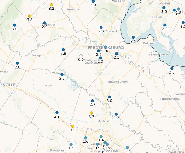
(Snowfall courtesy of CoCoRaHS – https://www.cocorahs.org/Maps/)
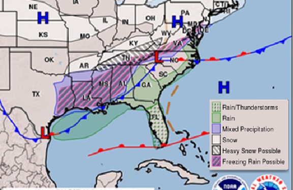
This storm was due to what meteorologists called “overrunning”. This happens when a frontal boundary is stalled just south of an area, with cold air to the north and warm air south of the boundary. There usually are several weak areas of low pressure that ride along the boundary, which are a reflection of upper-level impulses riding over the boundary. These impulses and lows act to increase precipitation across the region. If it’s cold enough, we get wintry precipitation on the north side. This is what happened with our event.

(Monday morning weather map showing position of frontal boundary to our south – NOAA/NWS)
The first period of snow was very light with most getting a dusting. The second, was associated with a stronger impulse and associated area of low pressure, and brought us the steady light to occasionally moderate snow Monday afternoon into the evening. A third system is moving this Tuesday morning with some light freezing rain.
Our next chance for snow is Friday, then the pattern changes back to warmth for the last 7-10 days of January.

I grew up an Air Force Brat. Traveled the country and lived in Georgia, Maine, New York, Hawaii and Oklahoma.
I fell in love with the weather in Oklahoma. My father was transferred to Tinker AFB in 1973. While in Temporary housing (a mobile home, which is the standard in Oklahoma) I experienced my first severe thunderstorm with strong winds and hail the size of baseballs. The next day I was in the base library looking up books on weather. The rest is history.
I graduated from the University of Oklahoma in 1983 with a Bachelor’s Degree in Meteorology. The first two years we took Calculus, Differential equations, Physics, Chemistry and Computer science classes with the Engineering Students. It was a grind. My degree is actually from the College of Engineering. The last 2-3 year’s focus was on Meteorology including Observational networks (Satellite, Radar, Surface), Physics, Thermodynamics, Dynamics, Synoptic, Winter Weather, Severe Weather and Climatology.
My first job out of college was with a small forecasting company in Oklahoma City. I was immediately put on TV (OETA) and Radio (WKY) as their broadcast Meteorologist. After two years in broadcasting, I decided to pursue the National Weather Service route and got a position in Toledo, OH as an intern. After a couple of years, I was promoted to a forecaster position at the Cleveland Forecast office. I quickly moved into the Weather Preparedness position and was responsible for all the preparedness activities in the state of Ohio.
In 1992 I decided to pursue other forecast opportunities and moved to the Meteorological Operations Division of the National Meteorological Center in Washington, DC. This group is now called WPC (Weather Prediction Center). There I fine-tuned my forecasting of Synoptic Weather with my focus on Heavy Convective Rainfall and Winter Storms, under the supervision of Dr. Louis Uccellini. He has written several books on East Coast Winter storms. I was promoted to a Senior Branch Forecast position during my tenure at MOD. Part of my job was to teach weather classes at COMET (Cooperative Program for Operational Meteorology, Education, and Training).
In 2012 I was given the opportunity to start up a new weather support group with the FAA (Federal Aviation Administration) in Warrenton, VA at the ATCSSC (Air Traffic Control System Command Center). The ATCSCC is where the FAA identifies solutions to air traffic inefficiencies in the NAS (National Air Space) for the CONUS (Continental United State). Weather impacts are the biggest impact on Aviation with yearly losses over 20 billion dollars. My job was to help lower these inefficiencies/costs by providing weather impact briefings and forecasts in order to keep the air planes moving as safely and efficiently as possible.
I retired in 2022 and now am running Lake Anna Weather, LLC.
Subscribe for Updates
Sponsors
latest articles
Five Decades of Innovation in Fishing, and Boating Sustainability at Lake Anna
Letter from the Editor: I Want to Believe

Staying Connected in Marriage: Tips for Nurturing Long-Term Connection for Life
Rescue and Therapy Dog Efforts Shape Mission at Virginia Poodles & Doodles

Lisa Marie Day Wins First-Ever Lake Anna Idol; Local Competition to Return Next Year

Beau’s Perspective: Hard Times and Crunchy Worm

Lake Anna’s first decent snowfall since the storm of Jan 2022. A pretty consistent range of 2-3” for much of the area.

(Snowfall courtesy of CoCoRaHS – https://www.cocorahs.org/Maps/)
This storm was due to what meteorologists called “overrunning”. This happens when a frontal boundary is stalled just south of an area, with cold air to the north and warm air south of the boundary. There usually are several weak areas of low pressure that ride along the boundary, which are a reflection of upper-level impulses riding over the boundary. These impulses and lows act to increase precipitation across the region. If it’s cold enough, we get wintry precipitation on the north side. This is what happened with our event.

(Monday morning weather map showing position of frontal boundary to our south – NOAA/NWS)
The first period of snow was very light with most getting a dusting. The second, was associated with a stronger impulse and associated area of low pressure, and brought us the steady light to occasionally moderate snow Monday afternoon into the evening. A third system is moving this Tuesday morning with some light freezing rain.
Our next chance for snow is Friday, then the pattern changes back to warmth for the last 7-10 days of January.

I grew up an Air Force Brat. Traveled the country and lived in Georgia, Maine, New York, Hawaii and Oklahoma.
I fell in love with the weather in Oklahoma. My father was transferred to Tinker AFB in 1973. While in Temporary housing (a mobile home, which is the standard in Oklahoma) I experienced my first severe thunderstorm with strong winds and hail the size of baseballs. The next day I was in the base library looking up books on weather. The rest is history.
I graduated from the University of Oklahoma in 1983 with a Bachelor’s Degree in Meteorology. The first two years we took Calculus, Differential equations, Physics, Chemistry and Computer science classes with the Engineering Students. It was a grind. My degree is actually from the College of Engineering. The last 2-3 year’s focus was on Meteorology including Observational networks (Satellite, Radar, Surface), Physics, Thermodynamics, Dynamics, Synoptic, Winter Weather, Severe Weather and Climatology.
My first job out of college was with a small forecasting company in Oklahoma City. I was immediately put on TV (OETA) and Radio (WKY) as their broadcast Meteorologist. After two years in broadcasting, I decided to pursue the National Weather Service route and got a position in Toledo, OH as an intern. After a couple of years, I was promoted to a forecaster position at the Cleveland Forecast office. I quickly moved into the Weather Preparedness position and was responsible for all the preparedness activities in the state of Ohio.
In 1992 I decided to pursue other forecast opportunities and moved to the Meteorological Operations Division of the National Meteorological Center in Washington, DC. This group is now called WPC (Weather Prediction Center). There I fine-tuned my forecasting of Synoptic Weather with my focus on Heavy Convective Rainfall and Winter Storms, under the supervision of Dr. Louis Uccellini. He has written several books on East Coast Winter storms. I was promoted to a Senior Branch Forecast position during my tenure at MOD. Part of my job was to teach weather classes at COMET (Cooperative Program for Operational Meteorology, Education, and Training).
In 2012 I was given the opportunity to start up a new weather support group with the FAA (Federal Aviation Administration) in Warrenton, VA at the ATCSSC (Air Traffic Control System Command Center). The ATCSCC is where the FAA identifies solutions to air traffic inefficiencies in the NAS (National Air Space) for the CONUS (Continental United State). Weather impacts are the biggest impact on Aviation with yearly losses over 20 billion dollars. My job was to help lower these inefficiencies/costs by providing weather impact briefings and forecasts in order to keep the air planes moving as safely and efficiently as possible.
I retired in 2022 and now am running Lake Anna Weather, LLC.
Subscribe for Updates
Sponsors
latest articles
Five Decades of Innovation in Fishing, and Boating Sustainability at Lake Anna

Letter from the Editor: I Want to Believe

Staying Connected in Marriage: Tips for Nurturing Long-Term Connection for Life
Rescue and Therapy Dog Efforts Shape Mission at Virginia Poodles & Doodles

Lisa Marie Day Wins First-Ever Lake Anna Idol; Local Competition to Return Next Year

Beau’s Perspective: Hard Times and Crunchy Worm

Spotsylvania Tourism Growth Outpaces Statewide Averages with 35% Surge Since 2019
Article By Jen Bailey
![Featured image for “[Spotsylvania] New Speed Enforcement in School Zones”](https://lakeanna.online/wp-content/uploads/2025/09/Blog-pic-scaled.jpg)
[Spotsylvania] New Speed Enforcement in School Zones
Article By Jen Bailey


