As Winter fades in the rearview mirror, we need to turn our attention to the upcoming season. In 2023 we actually had very little severe thunderstorm activity, due to the drought. So, what will 2024 bring?
Usually, exiting an El Nino winter results in a slightly lower threat for severe thunderstorms, including tornadoes, hail and strong winds. But, so far this year, we have seen a fairly active and early severe weather season over the Central and Southern US. The first ever February tornado in Wisconsin and several tornadoes in/around the Chicago area in late March. Like seasonal snow forecasting, nobody really knows. But, being prepared is key.
Severe thunderstorms are defined by three different elements: tornadoes, winds greater than 58 mph, and hail of 1” diameter or greater. Lightning and heavy rain occur with every thunderstorm, but they do not define a severe thunderstorm. But, lightning and flash flooding kill more people in the US each year than the other three combined.
Tornadoes are defined as a rotating column of air, that develops from a thunderstorm. They normally develop on the SW flank of thunderstorms where they have access to undisturbed moisture and heat. Virginia only averages around 10 tornadoes per year and most are weak. Virginia’s biggest tornado outbreak occurred with the passage of the remnants of Hurricane Ivan in 2004. Thirty-eight tornadoes occurred that day, with many large and damaging tornadoes.
Winds of 58 mph or stronger also defines a severe thunderstorm. In some of the strongest thunderstorms, winds can exceed 100 mph. These tend to occur with large thunderstorm complexes that are called Derechos. Our last Derecho occurred the evening of June 29, 2012 with widespread winds of 70-90 mph. The strongest winds with thunderstorms are along the leading edge. A shelf cloud visibly defines the leading edge of stronger winds.
Hail of 1” or more in diameter is the third element that can define a severe thunderstorm. Hail of this size can dent cars and cause roof/siding damage, especially if accompanied by strong winds. Most hail events in VA are below 2”, but on rare occasions, we can get some very large hail.
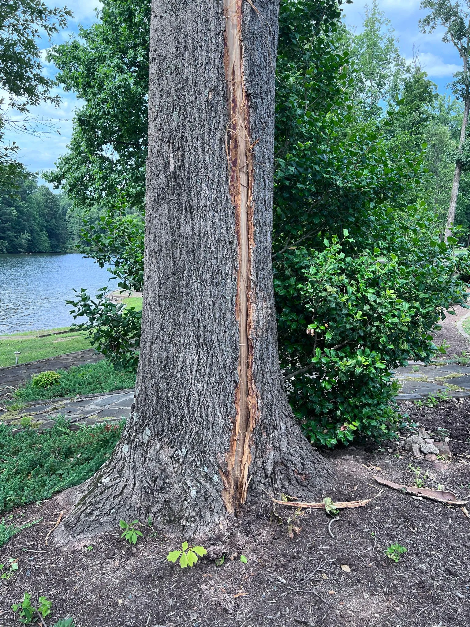
There are several ways of protecting yourself from lightning. The first is to get inside a building when a thunderstorm approaches. If you are caught outside, during a thunderstorm, you should stay away from hills, tall trees and open areas. Lightning tends to strike the highest thing around so the safest thing to do is get as low as possible. For people fishing, golfing or playing outdoor sports, you need to get off the water, golf course or field immediately. A good rule of thumb for lightning safety is the 30-30 rule. Once you see lightning, count until you hear the thunder. If it is 30 seconds or less, it’s time to get inside. Once the thunderstorm ends, wait an additional 30 minutes, from the last time you heard thunder or see lightning, before going back outside. Lightning has been known to strike several miles away from the main thunderstorm.
Watch -vs- Warning: Watches are issues for Tornadoes and Severe Thunderstorms. They are usually issued for a period of 6-8 hours and can cover areas almost the size of VA. If a watch is issued, that means there is the potential for the specific kind of weather. A tornado watch, includes the threat for severe thunderstorms, including Strong winds, Large Hail and Tornadoes. A Severe Thunderstorm Watch is issued for the threat of Strong Winds and Large Hail.
A warning is issued if either a Tornado, Strong winds or large hail is indicated by Radar and/or reported. Warnings usually are limited to one hour or less.This is the time to prepare for the upcoming severe weather season, by finding your safe place in your home or business. Make sure everyone knows where to go, so there is no delay.

I grew up an Air Force Brat. Traveled the country and lived in Georgia, Maine, New York, Hawaii and Oklahoma.
I fell in love with the weather in Oklahoma. My father was transferred to Tinker AFB in 1973. While in Temporary housing (a mobile home, which is the standard in Oklahoma) I experienced my first severe thunderstorm with strong winds and hail the size of baseballs. The next day I was in the base library looking up books on weather. The rest is history.
I graduated from the University of Oklahoma in 1983 with a Bachelor’s Degree in Meteorology. The first two years we took Calculus, Differential equations, Physics, Chemistry and Computer science classes with the Engineering Students. It was a grind. My degree is actually from the College of Engineering. The last 2-3 year’s focus was on Meteorology including Observational networks (Satellite, Radar, Surface), Physics, Thermodynamics, Dynamics, Synoptic, Winter Weather, Severe Weather and Climatology.
My first job out of college was with a small forecasting company in Oklahoma City. I was immediately put on TV (OETA) and Radio (WKY) as their broadcast Meteorologist. After two years in broadcasting, I decided to pursue the National Weather Service route and got a position in Toledo, OH as an intern. After a couple of years, I was promoted to a forecaster position at the Cleveland Forecast office. I quickly moved into the Weather Preparedness position and was responsible for all the preparedness activities in the state of Ohio.
In 1992 I decided to pursue other forecast opportunities and moved to the Meteorological Operations Division of the National Meteorological Center in Washington, DC. This group is now called WPC (Weather Prediction Center). There I fine-tuned my forecasting of Synoptic Weather with my focus on Heavy Convective Rainfall and Winter Storms, under the supervision of Dr. Louis Uccellini. He has written several books on East Coast Winter storms. I was promoted to a Senior Branch Forecast position during my tenure at MOD. Part of my job was to teach weather classes at COMET (Cooperative Program for Operational Meteorology, Education, and Training).
In 2012 I was given the opportunity to start up a new weather support group with the FAA (Federal Aviation Administration) in Warrenton, VA at the ATCSSC (Air Traffic Control System Command Center). The ATCSCC is where the FAA identifies solutions to air traffic inefficiencies in the NAS (National Air Space) for the CONUS (Continental United State). Weather impacts are the biggest impact on Aviation with yearly losses over 20 billion dollars. My job was to help lower these inefficiencies/costs by providing weather impact briefings and forecasts in order to keep the air planes moving as safely and efficiently as possible.
I retired in 2022 and now am running Lake Anna Weather, LLC.
Subscribe for Updates
Sponsors
latest articles
[Spotsylvania] New Speed Enforcement in School Zones
![Featured image for “[Spotsylvania] New Speed Enforcement in School Zones”](https://lakeanna.online/wp-content/uploads/2025/09/Blog-pic-scaled.jpg)
“Say Yes to the Address” with Mary Crowe: A Real Estate Story with Heart [Sponsored]
![Featured image for ““Say Yes to the Address” with Mary Crowe: A Real Estate Story with Heart [Sponsored]”](https://lakeanna.online/wp-content/uploads/2025/09/Blog-pic-3-scaled.png)
Birds on Power Lines? Don’t Shoot

Gordonsville’s Famous Fried Chicken Festival Clucks Into Town Saturday, October 4th [Sponsored]
![Featured image for “Gordonsville’s Famous Fried Chicken Festival Clucks Into Town Saturday, October 4th [Sponsored]”](https://lakeanna.online/wp-content/uploads/2025/08/wordandweekdays.com_-1.webp)
Contrary Creek Local Gordie Graham Wins National Wakeboarding Title at 27

Democracy, Critics & AI

As Winter fades in the rearview mirror, we need to turn our attention to the upcoming season. In 2023 we actually had very little severe thunderstorm activity, due to the drought. So, what will 2024 bring?
Usually, exiting an El Nino winter results in a slightly lower threat for severe thunderstorms, including tornadoes, hail and strong winds. But, so far this year, we have seen a fairly active and early severe weather season over the Central and Southern US. The first ever February tornado in Wisconsin and several tornadoes in/around the Chicago area in late March. Like seasonal snow forecasting, nobody really knows. But, being prepared is key.
Severe thunderstorms are defined by three different elements: tornadoes, winds greater than 58 mph, and hail of 1” diameter or greater. Lightning and heavy rain occur with every thunderstorm, but they do not define a severe thunderstorm. But, lightning and flash flooding kill more people in the US each year than the other three combined.
Tornadoes are defined as a rotating column of air, that develops from a thunderstorm. They normally develop on the SW flank of thunderstorms where they have access to undisturbed moisture and heat. Virginia only averages around 10 tornadoes per year and most are weak. Virginia’s biggest tornado outbreak occurred with the passage of the remnants of Hurricane Ivan in 2004. Thirty-eight tornadoes occurred that day, with many large and damaging tornadoes.
Winds of 58 mph or stronger also defines a severe thunderstorm. In some of the strongest thunderstorms, winds can exceed 100 mph. These tend to occur with large thunderstorm complexes that are called Derechos. Our last Derecho occurred the evening of June 29, 2012 with widespread winds of 70-90 mph. The strongest winds with thunderstorms are along the leading edge. A shelf cloud visibly defines the leading edge of stronger winds.
Hail of 1” or more in diameter is the third element that can define a severe thunderstorm. Hail of this size can dent cars and cause roof/siding damage, especially if accompanied by strong winds. Most hail events in VA are below 2”, but on rare occasions, we can get some very large hail.
There are several ways of protecting yourself from lightning. The first is to get inside a building when a thunderstorm approaches. If you are caught outside, during a thunderstorm, you should stay away from hills, tall trees and open areas. Lightning tends to strike the highest thing around so the safest thing to do is get as low as possible. For people fishing, golfing or playing outdoor sports, you need to get off the water, golf course or field immediately. A good rule of thumb for lightning safety is the 30-30 rule. Once you see lightning, count until you hear the thunder. If it is 30 seconds or less, it’s time to get inside. Once the thunderstorm ends, wait an additional 30 minutes, from the last time you heard thunder or see lightning, before going back outside. Lightning has been known to strike several miles away from the main thunderstorm.
Watch -vs- Warning: Watches are issues for Tornadoes and Severe Thunderstorms. They are usually issued for a period of 6-8 hours and can cover areas almost the size of VA. If a watch is issued, that means there is the potential for the specific kind of weather. A tornado watch, includes the threat for severe thunderstorms, including Strong winds, Large Hail and Tornadoes. A Severe Thunderstorm Watch is issued for the threat of Strong Winds and Large Hail.
A warning is issued if either a Tornado, Strong winds or large hail is indicated by Radar and/or reported. Warnings usually are limited to one hour or less.This is the time to prepare for the upcoming severe weather season, by finding your safe place in your home or business. Make sure everyone knows where to go, so there is no delay.

I grew up an Air Force Brat. Traveled the country and lived in Georgia, Maine, New York, Hawaii and Oklahoma.
I fell in love with the weather in Oklahoma. My father was transferred to Tinker AFB in 1973. While in Temporary housing (a mobile home, which is the standard in Oklahoma) I experienced my first severe thunderstorm with strong winds and hail the size of baseballs. The next day I was in the base library looking up books on weather. The rest is history.
I graduated from the University of Oklahoma in 1983 with a Bachelor’s Degree in Meteorology. The first two years we took Calculus, Differential equations, Physics, Chemistry and Computer science classes with the Engineering Students. It was a grind. My degree is actually from the College of Engineering. The last 2-3 year’s focus was on Meteorology including Observational networks (Satellite, Radar, Surface), Physics, Thermodynamics, Dynamics, Synoptic, Winter Weather, Severe Weather and Climatology.
My first job out of college was with a small forecasting company in Oklahoma City. I was immediately put on TV (OETA) and Radio (WKY) as their broadcast Meteorologist. After two years in broadcasting, I decided to pursue the National Weather Service route and got a position in Toledo, OH as an intern. After a couple of years, I was promoted to a forecaster position at the Cleveland Forecast office. I quickly moved into the Weather Preparedness position and was responsible for all the preparedness activities in the state of Ohio.
In 1992 I decided to pursue other forecast opportunities and moved to the Meteorological Operations Division of the National Meteorological Center in Washington, DC. This group is now called WPC (Weather Prediction Center). There I fine-tuned my forecasting of Synoptic Weather with my focus on Heavy Convective Rainfall and Winter Storms, under the supervision of Dr. Louis Uccellini. He has written several books on East Coast Winter storms. I was promoted to a Senior Branch Forecast position during my tenure at MOD. Part of my job was to teach weather classes at COMET (Cooperative Program for Operational Meteorology, Education, and Training).
In 2012 I was given the opportunity to start up a new weather support group with the FAA (Federal Aviation Administration) in Warrenton, VA at the ATCSSC (Air Traffic Control System Command Center). The ATCSCC is where the FAA identifies solutions to air traffic inefficiencies in the NAS (National Air Space) for the CONUS (Continental United State). Weather impacts are the biggest impact on Aviation with yearly losses over 20 billion dollars. My job was to help lower these inefficiencies/costs by providing weather impact briefings and forecasts in order to keep the air planes moving as safely and efficiently as possible.
I retired in 2022 and now am running Lake Anna Weather, LLC.
Subscribe for Updates
Sponsors
latest articles
[Spotsylvania] New Speed Enforcement in School Zones
![Featured image for “[Spotsylvania] New Speed Enforcement in School Zones”](https://lakeanna.online/wp-content/uploads/2025/09/Blog-pic-scaled.jpg)
“Say Yes to the Address” with Mary Crowe: A Real Estate Story with Heart [Sponsored]
![Featured image for ““Say Yes to the Address” with Mary Crowe: A Real Estate Story with Heart [Sponsored]”](https://lakeanna.online/wp-content/uploads/2025/09/Blog-pic-3-scaled.png)
Birds on Power Lines? Don’t Shoot

Gordonsville’s Famous Fried Chicken Festival Clucks Into Town Saturday, October 4th [Sponsored]
![Featured image for “Gordonsville’s Famous Fried Chicken Festival Clucks Into Town Saturday, October 4th [Sponsored]”](https://lakeanna.online/wp-content/uploads/2025/08/wordandweekdays.com_-1.webp)
Contrary Creek Local Gordie Graham Wins National Wakeboarding Title at 27

Democracy, Critics & AI

![Featured image for “[Spotsylvania] New Speed Enforcement in School Zones”](https://lakeanna.online/wp-content/uploads/2025/09/Blog-pic-scaled.jpg)
[Spotsylvania] New Speed Enforcement in School Zones
Article By Jen Bailey

Belmont Ruritan Clubs Award $26,000 in Scholarships to Local Seniors
Article By Jen Bailey


