
Amicroclimate is defined as atmospheric conditions that are slightly different from the larger areal climate conditions. Some of these can be significant differences that create impacts. Microclimates exist in many areas like cities (heat island) and around lakes, oceans, and mountainous areas.
Lake Anna is unique due to the Nuclear Power Plant that artificially warms the water over portions of the lake.
Since moving to Lake Anna, I have noticed several distinct atmospheric variables that the lake influences, and I have learned how to use this information to improve my forecasts.
Winter temperature is the first variable that the lake impacts. This occurs on the private (warm) side more than other areas, but all areas within a mile of the lake tend to be warmer than the surrounding areas that are several miles or more from the lake. A good example occurred during our January cold spell. I left Fredericksburg, and the temperature was 19 degrees F. As I left the city, the temperature dropped into the lower teens, and then when I drove through the Sturgeon Creek and 208 bridge areas, the temperature rose back up into the upper teens. The heat from the warmer water is transferred to the air. The lake warmth tends to prolong the growing season along the immediate shoreline.
In summer, the opposite happens on the cold side, where water temperatures are usually in the upper 80s, and this helps to keep the nearshore daytime temperatures slightly cooler than surrounding areas. But on the warm side, the water temperatures are much warmer, which tends to keep those areas much warmer, especially at night.
Wind forecasts are generally around 5-10 mph too low, especially after cold fronts move through the region. This is due to the open water areas that create less friction versus the forested areas around the lake. This impact is more noticeable around the more open areas of the lake, such as above Tims, the splits, and down lake. A west wind seems to be the most impactful wind for the lake since the lake is pretty much oriented west to east. A strong west wind will create bigger waves due to the longer time the wind blows over the lake. This is called Fetch.
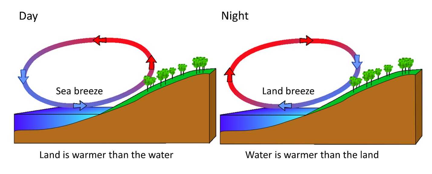
In summer and during calm nights, we can get lake-induced wind circulations. The water is very warm, while the land cools overnight. This causes less dense air over the warmer lake to rise, while the air over the surrounding land is cooler, denser, and sinks. This results in what we call a “land breeze” or winds blowing from the land to the lake in the morning hours. This process reverses itself in the hot afternoons with light winds.
Fog is another microclimate variable that is much more prevalent around the lake. Again, this is due to the warmer waters that support more evaporation of moisture into the atmosphere. This is very prevalent during the fall and winter and when winds are calm. The warm side can have days of steam coming off the water during the really cold outbreaks, like we had in January.
Some say that the lake tends to split thunderstorms, but I don’t think the lake is big enough to really impact well-organized thunderstorms. We had several days with lines of storms crossing the lake during the summer of 2024. Sometimes isolated thunderstorms will hit one portion of the lake while completely missing another part. The lake is about 17 miles long and, in some areas, 2-3 miles across. Isolated thunderstorms can be 2-3 miles in diameter, so yes, it’s possible to miss some storms at times.
I grew up an Air Force Brat. Traveled the country and lived in Georgia, Maine, New York, Hawaii and Oklahoma.
I fell in love with the weather in Oklahoma. My father was transferred to Tinker AFB in 1973. While in Temporary housing (a mobile home, which is the standard in Oklahoma) I experienced my first severe thunderstorm with strong winds and hail the size of baseballs. The next day I was in the base library looking up books on weather. The rest is history.
I graduated from the University of Oklahoma in 1983 with a Bachelor’s Degree in Meteorology. The first two years we took Calculus, Differential equations, Physics, Chemistry and Computer science classes with the Engineering Students. It was a grind. My degree is actually from the College of Engineering. The last 2-3 year’s focus was on Meteorology including Observational networks (Satellite, Radar, Surface), Physics, Thermodynamics, Dynamics, Synoptic, Winter Weather, Severe Weather and Climatology.
My first job out of college was with a small forecasting company in Oklahoma City. I was immediately put on TV (OETA) and Radio (WKY) as their broadcast Meteorologist. After two years in broadcasting, I decided to pursue the National Weather Service route and got a position in Toledo, OH as an intern. After a couple of years, I was promoted to a forecaster position at the Cleveland Forecast office. I quickly moved into the Weather Preparedness position and was responsible for all the preparedness activities in the state of Ohio.
In 1992 I decided to pursue other forecast opportunities and moved to the Meteorological Operations Division of the National Meteorological Center in Washington, DC. This group is now called WPC (Weather Prediction Center). There I fine-tuned my forecasting of Synoptic Weather with my focus on Heavy Convective Rainfall and Winter Storms, under the supervision of Dr. Louis Uccellini. He has written several books on East Coast Winter storms. I was promoted to a Senior Branch Forecast position during my tenure at MOD. Part of my job was to teach weather classes at COMET (Cooperative Program for Operational Meteorology, Education, and Training).
In 2012 I was given the opportunity to start up a new weather support group with the FAA (Federal Aviation Administration) in Warrenton, VA at the ATCSSC (Air Traffic Control System Command Center). The ATCSCC is where the FAA identifies solutions to air traffic inefficiencies in the NAS (National Air Space) for the CONUS (Continental United State). Weather impacts are the biggest impact on Aviation with yearly losses over 20 billion dollars. My job was to help lower these inefficiencies/costs by providing weather impact briefings and forecasts in order to keep the air planes moving as safely and efficiently as possible.
I retired in 2022 and now am running Lake Anna Weather, LLC.
Subscribe for Updates
Sponsors


latest articles
April 21, 2026
Lake Anna Development Continues: Data Centers, Dominion Updates, Roundabout Plaza, New Golf Course & Phosphorus and Hydrilla Management Reports at the 2026 Lake Anna Summit
April 18, 2026
From Louisa County to Hospital Halls: How Virginia Poodles & Doodles Is Making a Broader Impact

April 15, 2026
Lake Anna Waterfront Property | Custom Lake Home for Sale | Lake Anna, VA
March 18, 2026
Puppy Culture, Playgrounds & Early Foundations: How Virginia Poodles & Doodles Raises Confident Companions [Sponsored]
![Featured image for “Puppy Culture, Playgrounds & Early Foundations: How Virginia Poodles & Doodles Raises Confident Companions [Sponsored]”](https://lakeanna.online/wp-content/uploads/2026/02/3-scaled.jpg)
March 2, 2026
The Lion’s Den 1837 Celebrates First Anniversary With Black Tie Evening of Fine Dining and Jazz
February 27, 2026
Five Decades of Innovation in Fishing, and Boating Sustainability at Lake Anna
Amicroclimate is defined as atmospheric conditions that are slightly different from the larger areal climate conditions. Some of these can be significant differences that create impacts. Microclimates exist in many areas like cities (heat island) and around lakes, oceans, and mountainous areas.
Lake Anna is unique due to the Nuclear Power Plant that artificially warms the water over portions of the lake.
Since moving to Lake Anna, I have noticed several distinct atmospheric variables that the lake influences, and I have learned how to use this information to improve my forecasts.
Winter temperature is the first variable that the lake impacts. This occurs on the private (warm) side more than other areas, but all areas within a mile of the lake tend to be warmer than the surrounding areas that are several miles or more from the lake. A good example occurred during our January cold spell. I left Fredericksburg, and the temperature was 19 degrees F. As I left the city, the temperature dropped into the lower teens, and then when I drove through the Sturgeon Creek and 208 bridge areas, the temperature rose back up into the upper teens. The heat from the warmer water is transferred to the air. The lake warmth tends to prolong the growing season along the immediate shoreline.
In summer, the opposite happens on the cold side, where water temperatures are usually in the upper 80s, and this helps to keep the nearshore daytime temperatures slightly cooler than surrounding areas. But on the warm side, the water temperatures are much warmer, which tends to keep those areas much warmer, especially at night.
Wind forecasts are generally around 5-10 mph too low, especially after cold fronts move through the region. This is due to the open water areas that create less friction versus the forested areas around the lake. This impact is more noticeable around the more open areas of the lake, such as above Tims, the splits, and down lake. A west wind seems to be the most impactful wind for the lake since the lake is pretty much oriented west to east. A strong west wind will create bigger waves due to the longer time the wind blows over the lake. This is called Fetch.
In summer and during calm nights, we can get lake-induced wind circulations. The water is very warm, while the land cools overnight. This causes less dense air over the warmer lake to rise, while the air over the surrounding land is cooler, denser, and sinks. This results in what we call a “land breeze” or winds blowing from the land to the lake in the morning hours. This process reverses itself in the hot afternoons with light winds.
Fog is another microclimate variable that is much more prevalent around the lake. Again, this is due to the warmer waters that support more evaporation of moisture into the atmosphere. This is very prevalent during the fall and winter and when winds are calm. The warm side can have days of steam coming off the water during the really cold outbreaks, like we had in January.
Some say that the lake tends to split thunderstorms, but I don’t think the lake is big enough to really impact well-organized thunderstorms. We had several days with lines of storms crossing the lake during the summer of 2024. Sometimes isolated thunderstorms will hit one portion of the lake while completely missing another part. The lake is about 17 miles long and, in some areas, 2-3 miles across. Isolated thunderstorms can be 2-3 miles in diameter, so yes, it’s possible to miss some storms at times.
I grew up an Air Force Brat. Traveled the country and lived in Georgia, Maine, New York, Hawaii and Oklahoma.
I fell in love with the weather in Oklahoma. My father was transferred to Tinker AFB in 1973. While in Temporary housing (a mobile home, which is the standard in Oklahoma) I experienced my first severe thunderstorm with strong winds and hail the size of baseballs. The next day I was in the base library looking up books on weather. The rest is history.
I graduated from the University of Oklahoma in 1983 with a Bachelor’s Degree in Meteorology. The first two years we took Calculus, Differential equations, Physics, Chemistry and Computer science classes with the Engineering Students. It was a grind. My degree is actually from the College of Engineering. The last 2-3 year’s focus was on Meteorology including Observational networks (Satellite, Radar, Surface), Physics, Thermodynamics, Dynamics, Synoptic, Winter Weather, Severe Weather and Climatology.
My first job out of college was with a small forecasting company in Oklahoma City. I was immediately put on TV (OETA) and Radio (WKY) as their broadcast Meteorologist. After two years in broadcasting, I decided to pursue the National Weather Service route and got a position in Toledo, OH as an intern. After a couple of years, I was promoted to a forecaster position at the Cleveland Forecast office. I quickly moved into the Weather Preparedness position and was responsible for all the preparedness activities in the state of Ohio.
In 1992 I decided to pursue other forecast opportunities and moved to the Meteorological Operations Division of the National Meteorological Center in Washington, DC. This group is now called WPC (Weather Prediction Center). There I fine-tuned my forecasting of Synoptic Weather with my focus on Heavy Convective Rainfall and Winter Storms, under the supervision of Dr. Louis Uccellini. He has written several books on East Coast Winter storms. I was promoted to a Senior Branch Forecast position during my tenure at MOD. Part of my job was to teach weather classes at COMET (Cooperative Program for Operational Meteorology, Education, and Training).
In 2012 I was given the opportunity to start up a new weather support group with the FAA (Federal Aviation Administration) in Warrenton, VA at the ATCSSC (Air Traffic Control System Command Center). The ATCSCC is where the FAA identifies solutions to air traffic inefficiencies in the NAS (National Air Space) for the CONUS (Continental United State). Weather impacts are the biggest impact on Aviation with yearly losses over 20 billion dollars. My job was to help lower these inefficiencies/costs by providing weather impact briefings and forecasts in order to keep the air planes moving as safely and efficiently as possible.
I retired in 2022 and now am running Lake Anna Weather, LLC.
Subscribe for Updates
Sponsors
latest articles
April 21, 2026
Lake Anna Development Continues: Data Centers, Dominion Updates, Roundabout Plaza, New Golf Course & Phosphorus and Hydrilla Management Reports at the 2026 Lake Anna Summit
April 18, 2026
From Louisa County to Hospital Halls: How Virginia Poodles & Doodles Is Making a Broader Impact
April 15, 2026
Lake Anna Waterfront Property | Custom Lake Home for Sale | Lake Anna, VA
March 18, 2026
Puppy Culture, Playgrounds & Early Foundations: How Virginia Poodles & Doodles Raises Confident Companions [Sponsored]
March 2, 2026
The Lion’s Den 1837 Celebrates First Anniversary With Black Tie Evening of Fine Dining and Jazz
February 27, 2026
Five Decades of Innovation in Fishing, and Boating Sustainability at Lake Anna
Spotsylvania Tourism Growth Outpaces Statewide Averages with 35% Surge Since 2019
SPOTSYLVANIA COUNTY, VA — Visitor spending in Spotsylvania County has soared nearly 35% since 2019, reflecting a strong rebound and…
Article By Jen Bailey
![Featured image for “[Spotsylvania] New Speed Enforcement in School Zones”](https://lakeanna.online/wp-content/uploads/2025/09/Blog-pic-scaled.jpg)
[Spotsylvania] New Speed Enforcement in School Zones
To curb speeding and improve student safety, Spotsylvania officials have announced the launch of an automated speed enforcement program in…
Article By Jen Bailey
Belmont Ruritan Clubs Award $26,000 in Scholarships to Local Seniors
Thirteen outstanding seniors from Louisa, Orange, and Spotsylvania counties were recognized Tuesday evening, June 3, as the Belmont Ruritan Club…