
Severe thunderstorms are defined by three different elements: tornadoes, winds greater than 58 mph, and hail of 1” diameter or greater. Lightning and heavy rain occur with every thunderstorm, but they do not define a severe thunderstorm. However, lightning and heavy rainfall (flash flooding) kill more people in the US each year than the other three combined.
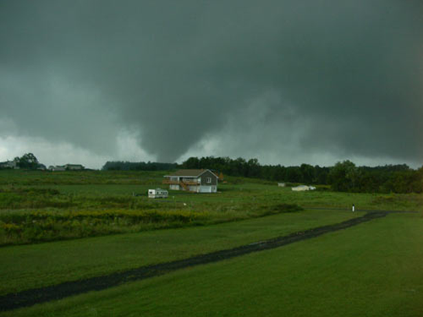
Tornadoes develop from a thunderstorm. They normally develop on the SW flank of a thunderstorm. Wind speeds can reach 200–300 mph in the strongest tornadoes. Virginia averages around 10 tornadoes per year, and most are weak. Virginia’s biggest tornado outbreak occurred with the passage of the remnants of Hurricane Ivan in 2004. Thirty-eight tornadoes occurred that day, with many large and damaging tornadoes.
Tornadoes are defined by the EF scale. The “E” stands for Enhanced and is basically where the damage is broken into finer detail, depending on types of trees, construction quality, etc. The F scale was initially developed by Ted Fujita, who was a professor at the University of Chicago. The scale ranges from zero to five, with five having the strongest winds.
We have seen a total of 41 tornadoes since 1950, which gives us an average of less than one per year. Most were weak, and there have been no deaths.
Winds of 58 mph or stronger also define a severe thunderstorm. In some of the strongest thunderstorms, winds can exceed 100 mph. These tend to occur with large thunderstorm complexes called derechos, but we can also get very localized strong winds with microbursts. This happened in June 2024 just above Rose Valley.
Hail of 1” or more in diameter is the third element that can define a severe thunderstorm. Hail of this size can dent cars and cause roof and siding damage, especially if accompanied by strong winds. Most hail events in VA are below 2”, but on rare occasions, we can get very large hail.
Watches are issued for tornadoes and severe thunderstorms. They are usually issued for a period of 6–8 hours and can cover areas almost the size of VA. If a watch is issued, that means there is the potential for that specific kind of weather.
A warning is issued if either a tornado, strong winds, or large hail is indicated by radar and/or reported. Warnings are usually limited to one hour or less.
In order to help you prepare for this upcoming severe weather season, I am pleased to announce that Louisa County will host the National Weather Service (NWS) and provide two training seminars on severe weather spotting and preparedness on March 12. This is in conjunction with Virginia’s Severe Weather Preparedness Week. The NWS Warning Coordination Meteorologist (WCM) at Wakefield, VA (which has responsibility for Louisa County), will be making the presentations.
One session will be for county employees such as police, firefighters, search and rescue personnel, and other first responders, along with other county staff.
The second session will be open to the public and will be held at 6:30 p.m. at the Alan Jackson Theater at Louisa County High School, 757 Davis Highway, Mineral, VA 23117.
The NWS Basic SKYWARN topics include information on severe weather ingredients, the role of spotters and why we need them, as well as weather safety tips.
To signup for the Skywarn session, go to https://lakeanna.online/skywarn.
I grew up an Air Force Brat. Traveled the country and lived in Georgia, Maine, New York, Hawaii and Oklahoma.
I fell in love with the weather in Oklahoma. My father was transferred to Tinker AFB in 1973. While in Temporary housing (a mobile home, which is the standard in Oklahoma) I experienced my first severe thunderstorm with strong winds and hail the size of baseballs. The next day I was in the base library looking up books on weather. The rest is history.
I graduated from the University of Oklahoma in 1983 with a Bachelor’s Degree in Meteorology. The first two years we took Calculus, Differential equations, Physics, Chemistry and Computer science classes with the Engineering Students. It was a grind. My degree is actually from the College of Engineering. The last 2-3 year’s focus was on Meteorology including Observational networks (Satellite, Radar, Surface), Physics, Thermodynamics, Dynamics, Synoptic, Winter Weather, Severe Weather and Climatology.
My first job out of college was with a small forecasting company in Oklahoma City. I was immediately put on TV (OETA) and Radio (WKY) as their broadcast Meteorologist. After two years in broadcasting, I decided to pursue the National Weather Service route and got a position in Toledo, OH as an intern. After a couple of years, I was promoted to a forecaster position at the Cleveland Forecast office. I quickly moved into the Weather Preparedness position and was responsible for all the preparedness activities in the state of Ohio.
In 1992 I decided to pursue other forecast opportunities and moved to the Meteorological Operations Division of the National Meteorological Center in Washington, DC. This group is now called WPC (Weather Prediction Center). There I fine-tuned my forecasting of Synoptic Weather with my focus on Heavy Convective Rainfall and Winter Storms, under the supervision of Dr. Louis Uccellini. He has written several books on East Coast Winter storms. I was promoted to a Senior Branch Forecast position during my tenure at MOD. Part of my job was to teach weather classes at COMET (Cooperative Program for Operational Meteorology, Education, and Training).
In 2012 I was given the opportunity to start up a new weather support group with the FAA (Federal Aviation Administration) in Warrenton, VA at the ATCSSC (Air Traffic Control System Command Center). The ATCSCC is where the FAA identifies solutions to air traffic inefficiencies in the NAS (National Air Space) for the CONUS (Continental United State). Weather impacts are the biggest impact on Aviation with yearly losses over 20 billion dollars. My job was to help lower these inefficiencies/costs by providing weather impact briefings and forecasts in order to keep the air planes moving as safely and efficiently as possible.
I retired in 2022 and now am running Lake Anna Weather, LLC.
Subscribe for Updates
Sponsors


latest articles
April 21, 2026
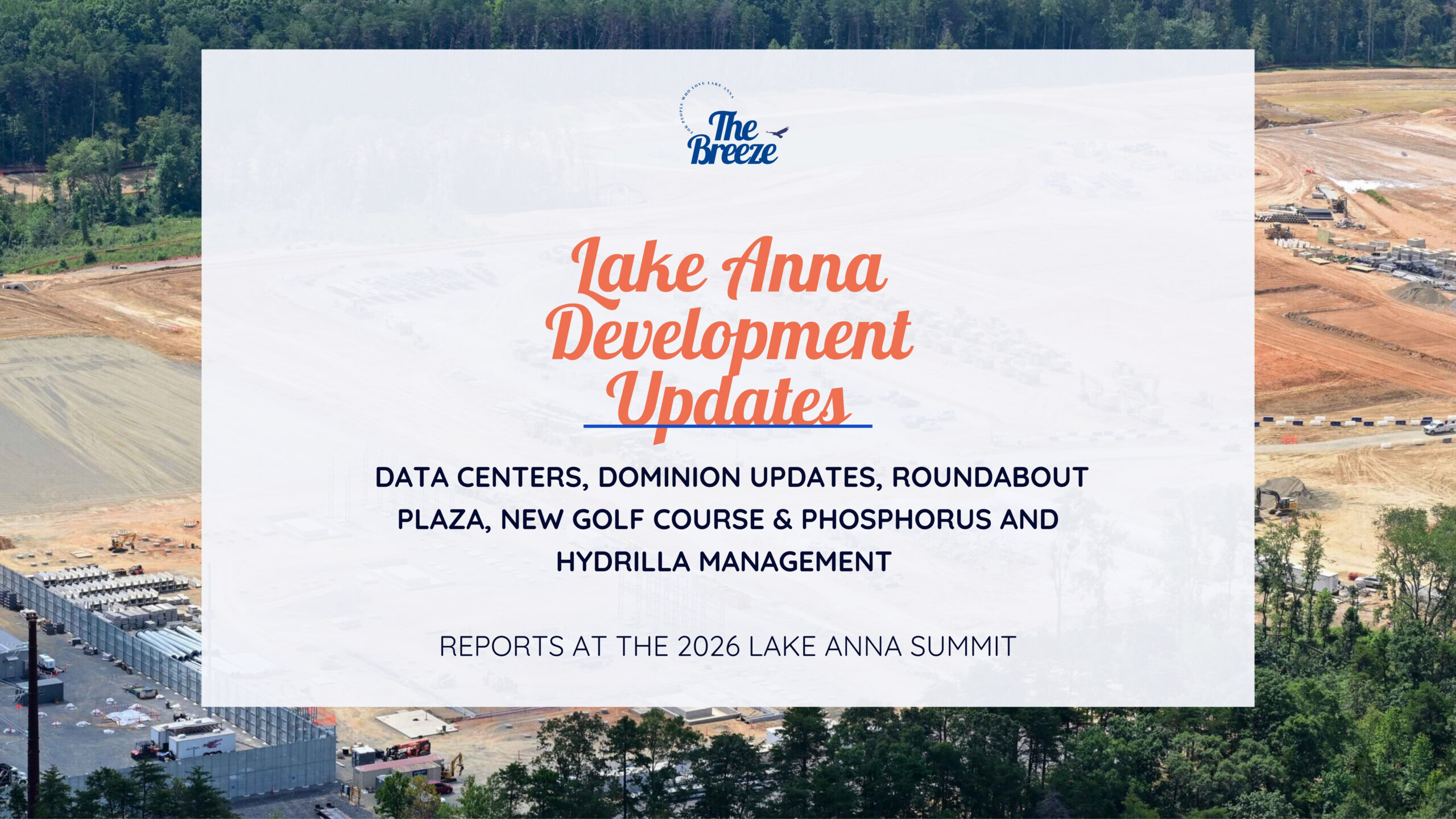
Lake Anna Development Continues: Data Centers, Dominion Updates, Roundabout Plaza, New Golf Course & Phosphorus and Hydrilla Management Reports at the 2026 Lake Anna Summit
April 18, 2026
From Louisa County to Hospital Halls: How Virginia Poodles & Doodles Is Making a Broader Impact

April 15, 2026
Lake Anna Waterfront Property | Custom Lake Home for Sale | Lake Anna, VA
March 18, 2026
Puppy Culture, Playgrounds & Early Foundations: How Virginia Poodles & Doodles Raises Confident Companions [Sponsored]
![Featured image for “Puppy Culture, Playgrounds & Early Foundations: How Virginia Poodles & Doodles Raises Confident Companions [Sponsored]”](https://lakeanna.online/wp-content/uploads/2026/02/3-scaled.jpg)
March 2, 2026
The Lion’s Den 1837 Celebrates First Anniversary With Black Tie Evening of Fine Dining and Jazz
February 27, 2026
Five Decades of Innovation in Fishing, and Boating Sustainability at Lake Anna
Severe thunderstorms are defined by three different elements: tornadoes, winds greater than 58 mph, and hail of 1” diameter or greater. Lightning and heavy rain occur with every thunderstorm, but they do not define a severe thunderstorm. However, lightning and heavy rainfall (flash flooding) kill more people in the US each year than the other three combined.
Tornadoes develop from a thunderstorm. They normally develop on the SW flank of a thunderstorm. Wind speeds can reach 200–300 mph in the strongest tornadoes. Virginia averages around 10 tornadoes per year, and most are weak. Virginia’s biggest tornado outbreak occurred with the passage of the remnants of Hurricane Ivan in 2004. Thirty-eight tornadoes occurred that day, with many large and damaging tornadoes.
Tornadoes are defined by the EF scale. The “E” stands for Enhanced and is basically where the damage is broken into finer detail, depending on types of trees, construction quality, etc. The F scale was initially developed by Ted Fujita, who was a professor at the University of Chicago. The scale ranges from zero to five, with five having the strongest winds.
We have seen a total of 41 tornadoes since 1950, which gives us an average of less than one per year. Most were weak, and there have been no deaths.
Winds of 58 mph or stronger also define a severe thunderstorm. In some of the strongest thunderstorms, winds can exceed 100 mph. These tend to occur with large thunderstorm complexes called derechos, but we can also get very localized strong winds with microbursts. This happened in June 2024 just above Rose Valley.
Hail of 1” or more in diameter is the third element that can define a severe thunderstorm. Hail of this size can dent cars and cause roof and siding damage, especially if accompanied by strong winds. Most hail events in VA are below 2”, but on rare occasions, we can get very large hail.
Watches are issued for tornadoes and severe thunderstorms. They are usually issued for a period of 6–8 hours and can cover areas almost the size of VA. If a watch is issued, that means there is the potential for that specific kind of weather.
A warning is issued if either a tornado, strong winds, or large hail is indicated by radar and/or reported. Warnings are usually limited to one hour or less.
In order to help you prepare for this upcoming severe weather season, I am pleased to announce that Louisa County will host the National Weather Service (NWS) and provide two training seminars on severe weather spotting and preparedness on March 12. This is in conjunction with Virginia’s Severe Weather Preparedness Week. The NWS Warning Coordination Meteorologist (WCM) at Wakefield, VA (which has responsibility for Louisa County), will be making the presentations.
One session will be for county employees such as police, firefighters, search and rescue personnel, and other first responders, along with other county staff.
The second session will be open to the public and will be held at 6:30 p.m. at the Alan Jackson Theater at Louisa County High School, 757 Davis Highway, Mineral, VA 23117.
The NWS Basic SKYWARN topics include information on severe weather ingredients, the role of spotters and why we need them, as well as weather safety tips.
To signup for the Skywarn session, go to https://lakeanna.online/skywarn.
I grew up an Air Force Brat. Traveled the country and lived in Georgia, Maine, New York, Hawaii and Oklahoma.
I fell in love with the weather in Oklahoma. My father was transferred to Tinker AFB in 1973. While in Temporary housing (a mobile home, which is the standard in Oklahoma) I experienced my first severe thunderstorm with strong winds and hail the size of baseballs. The next day I was in the base library looking up books on weather. The rest is history.
I graduated from the University of Oklahoma in 1983 with a Bachelor’s Degree in Meteorology. The first two years we took Calculus, Differential equations, Physics, Chemistry and Computer science classes with the Engineering Students. It was a grind. My degree is actually from the College of Engineering. The last 2-3 year’s focus was on Meteorology including Observational networks (Satellite, Radar, Surface), Physics, Thermodynamics, Dynamics, Synoptic, Winter Weather, Severe Weather and Climatology.
My first job out of college was with a small forecasting company in Oklahoma City. I was immediately put on TV (OETA) and Radio (WKY) as their broadcast Meteorologist. After two years in broadcasting, I decided to pursue the National Weather Service route and got a position in Toledo, OH as an intern. After a couple of years, I was promoted to a forecaster position at the Cleveland Forecast office. I quickly moved into the Weather Preparedness position and was responsible for all the preparedness activities in the state of Ohio.
In 1992 I decided to pursue other forecast opportunities and moved to the Meteorological Operations Division of the National Meteorological Center in Washington, DC. This group is now called WPC (Weather Prediction Center). There I fine-tuned my forecasting of Synoptic Weather with my focus on Heavy Convective Rainfall and Winter Storms, under the supervision of Dr. Louis Uccellini. He has written several books on East Coast Winter storms. I was promoted to a Senior Branch Forecast position during my tenure at MOD. Part of my job was to teach weather classes at COMET (Cooperative Program for Operational Meteorology, Education, and Training).
In 2012 I was given the opportunity to start up a new weather support group with the FAA (Federal Aviation Administration) in Warrenton, VA at the ATCSSC (Air Traffic Control System Command Center). The ATCSCC is where the FAA identifies solutions to air traffic inefficiencies in the NAS (National Air Space) for the CONUS (Continental United State). Weather impacts are the biggest impact on Aviation with yearly losses over 20 billion dollars. My job was to help lower these inefficiencies/costs by providing weather impact briefings and forecasts in order to keep the air planes moving as safely and efficiently as possible.
I retired in 2022 and now am running Lake Anna Weather, LLC.
Subscribe for Updates
Sponsors
latest articles
April 21, 2026
Lake Anna Development Continues: Data Centers, Dominion Updates, Roundabout Plaza, New Golf Course & Phosphorus and Hydrilla Management Reports at the 2026 Lake Anna Summit
April 18, 2026
From Louisa County to Hospital Halls: How Virginia Poodles & Doodles Is Making a Broader Impact
April 15, 2026
Lake Anna Waterfront Property | Custom Lake Home for Sale | Lake Anna, VA
March 18, 2026
Puppy Culture, Playgrounds & Early Foundations: How Virginia Poodles & Doodles Raises Confident Companions [Sponsored]
March 2, 2026
The Lion’s Den 1837 Celebrates First Anniversary With Black Tie Evening of Fine Dining and Jazz
February 27, 2026
Five Decades of Innovation in Fishing, and Boating Sustainability at Lake Anna
Spotsylvania Tourism Growth Outpaces Statewide Averages with 35% Surge Since 2019
SPOTSYLVANIA COUNTY, VA — Visitor spending in Spotsylvania County has soared nearly 35% since 2019, reflecting a strong rebound and…
Article By Jen Bailey
![Featured image for “[Spotsylvania] New Speed Enforcement in School Zones”](https://lakeanna.online/wp-content/uploads/2025/09/Blog-pic-scaled.jpg)
[Spotsylvania] New Speed Enforcement in School Zones
To curb speeding and improve student safety, Spotsylvania officials have announced the launch of an automated speed enforcement program in…
Article By Jen Bailey
Belmont Ruritan Clubs Award $26,000 in Scholarships to Local Seniors
Thirteen outstanding seniors from Louisa, Orange, and Spotsylvania counties were recognized Tuesday evening, June 3, as the Belmont Ruritan Club…